
You probably don’t think about it. You open Google Maps, tap “start,” and trust that a tiny chip in your pocket knows exactly where you are. You track your run. You wait for your food. It works. But have you ever actually wondered how a device with no eyes can pinpoint your location on a planet that is 7,900 miles wide?
Almost every smartphone has a GPS receiver. That means your phone is constantly talking to space. Specifically, it’s listening to a constellation of satellites that circle the Earth at incredible speeds. If you have a clear view of the sky, you’re never truly lost. But if you’re indoors, deep in a canyon, or under heavy tree cover, that signal drops. Understanding the mechanics behind this technology is useful. It explains why your location jumps around sometimes and why you need an internet connection to get full street names.
What Is GPS?
When people say “I’m using my GPS,” they usually mean the app on their phone. They’re referring to the receiver. But the Global Positioning System (GPS) itself is a massive network. It is not just one thing. It is a constellation of satellites.
The U.S. military built this system. Originally, it was for navigation, targeting, and coordination. Then, they opened it up. Now, civilians use it for everything from aviation to tracking package deliveries.
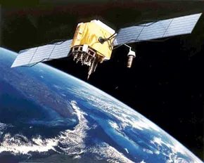
The infrastructure is heavy. Each satellite weighs between 3,000 and 4,000 pounds. They are solar-powered machines circling the Earth at an altitude of about 12,427 miles (20,000 km). They move fast. Each satellite completes two full orbits every 24 hours.
There are currently 31 operational satellites in orbit. Four more are classified as reserves or “unhealthy.” The geometry of their orbits is deliberate. The system is designed so that at any given time, anywhere on Earth, at least four satellites are “visible.”
That visibility is the key. Your phone doesn’t guess. It calculates. It uses these satellites to determine your precise location.
How Does GPS Work?
The process is surprisingly logical. Your GPS receiver looks up. It locks onto signals from four or more satellites. It measures the time it takes for those signals to arrive. From that time, it calculates the distance to each satellite.
This is where trilateration comes in.
Trilateration sounds complex. It is just geometry. In three-dimensional space, it can get tricky. So let’s break it down with a simpler example. Two-dimensional trilateration.
Imagine you are lost. Dead center in the United States. No map. No clue. You ask a local, “Where am I?”
He says, “You are 625 miles from Boise, Idaho.”
That is a fact. But it is not helpful on its own. You could be anywhere on a circle with Boise at the center and a radius of 625 miles.

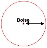
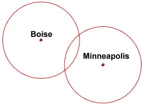
You ask someone else where you are, and she says, “You are 690 miles from Minneapolis, Minnesota.” Now you’re getting somewhere.
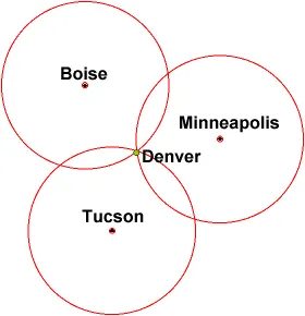
If you combine this information with the Boise information, you have two circles that intersect. You now know that you must be at one of these two intersection points, if you are 625 miles from Boise and 690 miles from Minneapolis:

This is the fundamental principle behind how GPS triangulation works. Each satellite provides a distance measurement, creating a sphere (not a circle, since we’re in 3D space) centered on that satellite. Your position is where these spheres intersect.
With two satellites, you get two intersection points. With three, you narrow it down to one point on Earth’s surface. But here’s the catch: there’s still ambiguity. Earth’s curvature and the satellite geometry mean you might have two possible locations—one on the surface and one out in space.
That’s why why GPS needs at least four satellites for accurate positioning. The fourth satellite resolves the time ambiguity. GPS receivers calculate position by measuring the time it takes for signals to travel from satellites. Since light travels at a fixed speed, time measurements translate directly to distance.
The precision of your location depends on several factors:
- Satellite geometry : Satellites spread across the sky provide better accuracy than those clustered in one direction
- Signal interference : Buildings, trees, and atmospheric conditions can delay or block signals
- Receiver quality : Military-grade receivers offer centimeter-level accuracy, while consumer devices typically achieve 5-10 meter precision
Modern smartphones use additional techniques like A-GPS (Assisted GPS), which downloads satellite location data from cell towers to speed up initial location fixes. This is where your location data gets complicated when you’re indoors or in urban canyons—GPS signals struggle, and phones fall back on Wi-Fi positioning, cellular triangulation, or inertial sensors.
The beauty of this system is that it works without you needing to know anything about satellites. Your phone just asks, “Where am I?” and the math figures it out.
Pinpointing Location with Three Circles
Getting accurate data from GPS satellites is more than just measuring distance. Work with intersecting geometries in 3D to solve latitude, longitude and elevation simultaneously. When a receiver communicates with multiple satellites, each satellite defines a set of possible locations. The device finds a single point where these spheres meet.
Therefore, the fix requires at least four satellites instead of three. These three satellites provide location on the earth’s surface, but the altitude is either unclear or derived rather than measured. The fourth satellite accounts for the timing errors inherent in the receiver’s internal clock. GPS satellites use atomic clocks. Accuracy is in nanoseconds. Your phone or car GPS unit does not. This clock offset is the main variable that the fourth satellite uses in its calculations.
“Three satellites intersect at two possible points in space. One is in space, usually far from Earth. The other is on Earth’s surface. The fourth satellite confirms what your true location is.”
Without the fourth satellite, the location can shift significantly vertically. You may think you’re at sea level, but you’re actually 1,000 feet above sea level. Even worse, the system locks up at the wrong intersection entirely. This is rare, but can happen in urban canyons where the signal bounces off buildings. Multipath errors occur when signals bounce off tall buildings before reaching the device. This makes the distance calculation look longer than it actually is.
Modern receivers use sophisticated algorithms to filter out these unwanted signals. They are looking for consistency across multiple satellites. If three satellites match and one satellite does not, the system may reject the anomaly. This is called Receiver Autonomous Integrity Monitoring (RAIM). The reflected signal misleads the GPS, making it impossible to follow directions to the lake.
The math behind this is elegant. Each satellite’s signal indicates its distance based on travel time. Multiply this time by the speed of light. You get a radius. Draw a circle around the ground track of each satellite. You are where the circles intersect. In theory, it’s easy. It’s actually complicated. The earth is moving. Satellites are moving. Atmospheric delays can slow down the signal. Refraction in the ionosphere and troposphere changes the speed of the signal. The receiver must model these effects in real time.
This is why GPS accuracy varies. Open sky gives an accuracy of 1-2 meters. Due to the dense forest cover, the water depth drops to more than 10 meters. In an urban environment, the error can be 20 meters. Assisted GPS uses cell towers to help you track satellites faster. This is A-GPS. It’s important for smartphones to be able to fix them quickly when you turn them on for the first time.
So when you see your location marked on the map, remember the network of invisible satellites orbiting above you. The geometry is tight. The timing is tight. The margin of error is small. This enables daily navigation.
The Geometry of Space
When the math stays flat, we call it 2D trilateration. The intersection points lie on a single plane. But once altitude enters the equation, the third dimension takes over. That is when 3D trilateration kicks in.
The concept is similar to the 2D version, but harder to wrap your head around. Instead of radii drawing circles on a map, imagine spheres expanding in every direction.
Let’s say you are 10 miles from satellite A. You could be anywhere on the surface of an imaginary sphere with that 10-mile radius. If you also know you are 15 miles from satellite B, you overlay a second, larger sphere.
The two spheres intersect in a perfect circle. Add a third satellite, and you get a third sphere. This new sphere cuts through the existing circle at exactly two points.
So, which one is you?
Earth itself acts as a fourth reference point. One of those two points is in space. The other is on the ground. The receiver simply discards the one in the vacuum. Most units, though, lock onto four or more satellites. This improves accuracy and provides precise altitude data rather than just a rough guess.
How GPS Devices Calculate Your Location
For a GPS receiver to work, it needs two specific pieces of information:
- The exact location of at least three satellites above you
- The distance between you and each of those satellites
The device determines both by analyzing high-frequency, low-power radio signals beamed from orbit. Higher-end units use multiple receivers. This allows them to lock onto several satellites at once without missing a beat.
Radio waves are electromagnetic energy. They travel at the speed of light. That is about 186,000 miles per second, or 300,000 km per second in a vacuum.
The receiver calculates distance by measuring time. It times how long the signal took to arrive.
GPS Math: Using Timing to Calculate Distance
There is nothing wrong with throwing the word “trilateration” into the conversation and sounding technical. But if you really want to impress your colleagues, you need to prepare for the inevitable next question. “How does the device actually measure the distance to a satellite orbiting hundreds of miles above?”
There is only one answer: timing.
Speed of light and signal delay
Imagine a specific moment, say midnight. GPS satellites begin transmitting long strings of numbers called pseudo-random codes. At the same time, the receiver starts playing an identical copy of the same digital pattern.
There is a delay when the satellite signal reaches your device. A local copy of the code precedes the signal from space. This delay is not a bug. This is the exact time it takes for a signal to travel through the vacuum of space.
Your receiver multiplies that delay by the speed of light. The result is the distance between you and the satellite. This calculation assumes that the signal propagates in a straight line. Realistically, this is a rough estimate, but it’s the basic math behind how GPS works.
Solving the Clock Problem
There is a massive catch here. For this timing method to work, the satellite and receiver clocks must be synchronized to within nanoseconds. A difference of one billionth of a second means a distance error of about 30 centimeters.
Achieving this level of accuracy typically requires an atomic clock. These devices are expensive, typically costing between $50,000 and $100,000 each. GPS satellites are funded by taxpayers, so they can afford to buy this equipment. However, if every smartphone or car navigation device required an atomic clock, the consumer market would collapse. Apple can’t sell an iPhone at this price.
GPS solves this problem with a smart solution. Each satellite is equipped with a very precise atomic clock. However, the receiver uses an inexpensive standard quartz clock.
The balance is: The receiver receives signals from at least four satellites. Compare the timing of these input signals with your own internal clock. By analyzing this difference, the receiver can calculate its own timing error. Constantly reset and correct your quartz watch based on satellite data. This process provides free smartphones with less accurate atomic clocks.
Correcting Atmospheric Errors
GPS is accurate, but it’s not perfect. This system assumes that radio signals travel at a constant speed. However, the Earth’s atmosphere slows down the signal. Tall buildings, mountains, and even dense foliage can reflect or block the signal path. These disturbances can cause errors in calculations.
Differential GPS (DGPS) exists to solve this problem. The concept is simple. Earth stations whose location is precisely known act as reference points. Fixed receivers calculate the difference between their actual position and the position reported by the GPS signal. This difference is the error.
The station then sends this correction information via radio signals to nearby DGPS-equipped devices. Recipients in the area apply this correction to their own calculations. The result is much higher accuracy than standard GPS alone can provide.
Key Definitions and Systems
Understanding the big picture will help you understand what you’re really using.
- GPS: Stands for Global Positioning System. Technically speaking, the “GPS system” is unnecessary. This is a special satellite network in the United States.
- GIS: Stands for Geographic Information System. This is different from GPS. GIS is software used to capture, store, analyze and display spatial data. This is a tool that visualizes the location data provided by GPS.
- GNSS: stands for Global Navigation Satellite System. GPS is only one part of this larger umbrella. GNSS also includes other systems such as Galileo (used in the EU) and Beidou (used in China).
Most modern devices use GNSS and acquire data from the most powerful satellite networks in the area. This means that your phone will not only receive US satellites. It is part of a global network of navigation infrastructure designed to help you stay oriented wherever you are.