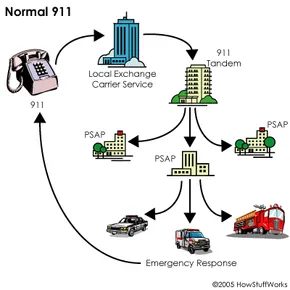
When you panic and dial 911, you aren’t just shouting into a void. The call gets routed straight to a public-safety answering point, or PSAP. These are the busy centers where trained operators take charge. Historically, they got two things: your voice and a callback number. Today, the stakes are higher. The expectation is precision.
Most areas in the US now utilize Enhanced 911 (E-911). This system gives dispatchers a general idea of where you are. But “general” can mean blocks away. And in an emergency, blocks matter. According to the Cellular Telephone Industry Association (CTIA), Americans make 150,000 emergency wireless calls every single day. That volume demands accuracy. The government knows this. That is why the Federal Communications Commission (FCC) has been pushing carriers to upgrade their location-finding tech.
The goal is simple. Pinpoint the exact position of a wireless emergency call.
The Phased Rollout of E-911
The FCC didn’t just flip a switch. They rolled out E-911 in phases. It was a slow grind of regulation and technology.
Phase 0 was the baseline. It established the basic process. Wireless calls go to a PSAP. Crucially, providers must accept these calls even if you aren’t a subscriber. You can use a stranger’s phone to save your life. The system allows it.
Phase I added a layer of accountability. The FCC mandated that every wireless 911 call display a phone number. Why? To allow the operator to call back if the connection drops. Silence is terrifying. A callback number cuts through it.
“The government has stepped in to ensure that E-911 capabilities are improved.”
This wasn’t optional. It was a rule.
Phase II is the heavy lifter. It is the final phase. Carriers were forced to integrate GPS receivers into phones. The objective? Specific latitude and longitude data. The accuracy standard is tight. Location information must be within 164 to 984 feet. That is 50 to 300 meters.
Why Location Precision Changes Everything
Consider the difference between Phase I and Phase II. Phase I gives a street address or a tower handoff. Phase II gives coordinates. In a city, the gap between an address and GPS coordinates can be a floor, a building entrance, or a specific apartment.
If you are stranded in a dense urban area, Phase I might tell the operator you are near “Main Street.” Phase II tells them you are on the second floor of 42 Main Street.
The FCC demanded this improvement because wireless technology evolved faster than emergency response protocols. As cell phones became the primary communication device, landline-era rules became obsolete. The FCC responded. They required carriers to adapt.
This isn’t just about convenience. It is about survival. The 150,000 daily calls represent real people in real danger. Every second counts. Every foot of error margin counts. The push for exact location data is a response to that urgency.
The Limitations of General Location
Even with E-911, many areas still struggle with precision. The text

The Precision of Phase II E-911
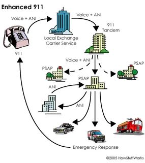
Without Phase II, emergency responders are flying blind regarding exact coordinates. They know which cell tower handled the call, but that’s a wide net. Phase II changes the game by sending more than just a ping. It transmits the caller’s phone number, or Automatic Number Identification (ANI), along with the specific address and location of the receiving antenna site directly to the E-911 Tandem. This switch routes the call to the correct Public Safety Answering Point (PSAP) based on geographic data tied to that ANI.
Once the voice and ANI hit the PSAP, the operator doesn’t just listen. They see a screen. A graphic display shows the precise longitude and latitude of the caller, pulled from GPS satellites. The computer links to the ALI database, which holds address records and other stored data. It is a shift from guesswork to verified data points.
Commercial Spillover and Privacy Risks
Phase II technology does not just help first responders. It opens doors for new commercial opportunities. Location-based services are already leveraging the E-911 infrastructure to push content to phones. Think targeted advertising. The infrastructure that finds you in an emergency can also find you at a coffee shop.
This convenience comes with a cost. Privacy concerns are mounting. We will look at those in the next section, but the tension is clear. The same data that saves lives can be used to track movement.
The Origin of the Three-Digit Code
The history of the number itself is almost as important as the technology. On February 16, 1968, Alabama Senator Rankin Fite made the first 911 call in the United States. It happened in Haleyville, Alabama. The Alabama Telephone Company carried the call. Just a week later, Nome, Alaska, rolled out its own system.
By 1973, the pressure was building. The White House’s Office of Telecommunication issued a national statement. They supported the use of 911. They pushed for a Federal Information Center to help government agencies implement the system everywhere.
Why 911 Was Selected
Why that specific combination? Prior to the 1960s, there was no universal number for emergency help. Communities used three-digit numbers, but they varied. In 1967, the Federal Communications Commission met with AT&T to establish a single standard. The National Emergency Number Association (NENA) cites this meeting as the starting point.
But why 911? Why not 422? Or 111?
The choice was strategic. It was short. Easy to remember in a panic. But more importantly, 911 was unique. It had never been designated for an office code. Not an area code. Not a service code. It was a blank slate in the dialing plan. This uniqueness made it the only viable candidate for a universal emergency number.